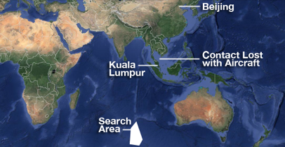
 KUALA LUMPUR, Malaysia–Raw satellite data released Tuesday by Malaysian authorities and a separate report issued by Australian accident investigators offered fresh support for views that missing Malaysia Airlines Flight 370 went down in a remote section of the Indian Ocean after running out of fuel.
The 45 pages of raw data–detailed communication logs between the aircraft and a satellite–were provided to the Department of Civil Aviation of Malaysia by satellite firm Inmarsat PLC. The released documents also include a two-page summary prepared by Inmarsat experts explaining how to read tables.
The release follows demands by the families of some of the 239 passengers and crew on Flight 370 to open analysis of the flight path to other experts. However, some family members were unhappy that the data and summary were difficult to understand.
“We do not understand the report. We need an expert to explain it to us, ” Sahril Shaari, the cousin of Muhammad Razahan Zamani, who was on Flight 370, told The Wall Street Journal.
Jonathan Galaviz, who heads the aviation practice at consulting firm Global Market Advisors, lauded the effort by Malaysia to be transparent and said the raw data will help universities or individual experts independently verify the analysis.
“The frustration (of families) is understandable. But no matter which way the government turns, it will be subject to criticism,” Mr. Galaviz said by telephone.
The summary notes are generally consistent with earlier public statements by investigators and Inmarsat, and don’t appear to shed new light on the techniques experts used to chart the presumed path of the jetliner after it veered off course, disappeared from radar and went missing in the early hours of March 8.
Investigators, including those from the United Kingdom, Australia and the U.S. have relied on Inmarsat data to conclude that the Boeing Co. 777 jet flew to the remote southern Indian Ocean, thousands of miles off course and far from any land mass, and then crashed after likely running out of fuel.
Investigators are still poring over the data in their effort to narrow down the search area, Hishammuddin Hussein, Malaysia’s defense and acting transport minister, told reporters on Monday. International experts have stood behind their calculations after repeated reviews of the satellite signals, and assumptions for flight speed, altitude and fuel consumption.
No flight-related debris has been found, even after a massive search involving 26 nations. The search for the missing aircraft will now focus on mapping the ocean floor around the area where experts believe Flight 370 crashed.
The long-awaited release of the data coincides with separate but similar explanations released by Australian air-accident investigators. Those documents included a few more details about the presumed accuracy of the series of so-called “digital handshakes” between the jet and a satellite orbiting more than 22,000 miles above the earth.
These results underscore investigators’ confidence in the technical analysis that underpins plans for a retooled search, expected to begin this summer. But based on skeptics’ previous reactions to the release of data, the information could provide ammunition for criticism.
According to the Australian Transport Safety Bureau, the possible path of the jet–sketched by a composite of satellite signals, calculations by Inmarsat and other experts and other jet signals–ultimately were determined by experts to be accurate to about 10 kilometers.
Included in Inmarsat’s data are two items likely to attract attention from outsiders trying to understand the sequence of events. The transmission log shows that roughly two hours after takeoff–by which time the plane’s routine satellite-messaging system had stopped functioning–Inmarsat’s system documented a “ground initiated” telephone call to the aircraft.
Investigators have said the system was deliberately turned off.
WSJ

Leave a Reply
You must be logged in to post a comment.