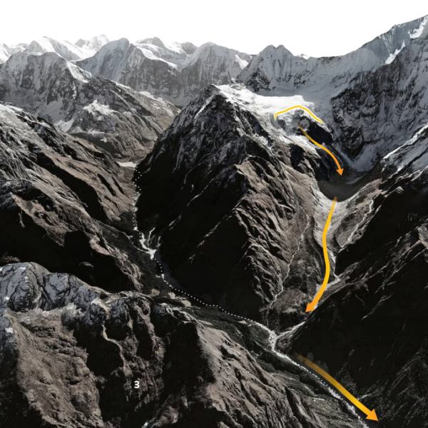
Aerial 3D terrain view of Nepal’s Langtang valley, snow-capped peaks below Langtang Lirung, with orange arrows tracing three stages: a glacier’s lower section collapsing, an ice-and-rock avalanche and debris flow sweeping down, then catastrophic flooding
The rapid landslide of ice and rock and flash floods that killed hundreds in Nepal and China’s Tibet were triggered when the lower part of a glacier broke off and crashed on to the valley floor hundreds of metres below.
Rescuers continued searching for survivors in the debris-strewn valleys and hillsides of Nepal on Thursday while more than 1,000 people remained missing there.
It is not clear what caused the glacier to collapse. Nepali officials initially pointed to an earthquake in the region as a possibility, but the U.S. Geological Survey later said the reported tremor was in fact seismic energy generated by the collapse of glacial rock and ice, followed by debris flow.
Satellite imagery shows a large part of a glacier near Langtang Lirung peak split off when compared with imagery taken a few days earlier.
Satellite images compare a Himalayan glacier before and after the landslide, with a size comparison to Dubai’s Burj Khalifa. An Aug 24 Sentinel-2 view labels the glacier terminus at 5,200 m altitude, and an Aug 26 Landsat 9 view shows landslide debris where the glacier broke.
An avalanche of ice and rock swept down the Lhende Khola river, which runs along the mountainous Nepal/Tibet border.
The mudslide slammed into Gyirong port in Tibet and into Nepal, creating high-speed flash floods that washed away entire roads and power projects and inundated villages.
Verified videos showed dozens of people swept away at the border.
Chinese government geologist Guo Zhaocheng said the ice-avalanche debris flow that caused the mudslide travelled at about 50 metres (165 feet) per second, leaving people little time to react, and extended for more than 20 km (12 miles).
Surveillance cameras mounted at Gyirong Port captured the moment the disaster unfolded, showing a massive, brownish mudflow surging down the canyon from the Nepalese valley, directly engulfing the Gyirong Port building and people attempting to escape.
Flood waters created by the collapse rushed through valleys in Nepal and altered river channels more than 100 km (62 miles) downstream, near the Indian border, after a descent of more than 4,500 metres (14,763 feet) in elevation from the Himalayas.
Elevation profile and terrain map tracing the Trishuli River over 100 km from a glacier at 5,127 m in China, where a collapse began, steeply down past Timure, Syapru Besi, Hakubesi, Betrawati, Trishuli and Devighat to Kolpurtar in Nepal below 500 m.
The Red Cross said that entire villages had been destroyed and impassable roads and bridges had left communities cut off. The full scale of the disaster remains unclear, it added.
“It was a huge gush of mud coming straight towards us,” said Keshav Prasad Baral, a 68-year-old survivor being treated in a Nepali hospital.
“As it got closer, it kept rising higher and higher. When I saw it enter our home, I tried to grab my wife’s hand and take her to the terrace. But she was swept away by the mud.”
The International Centre for Integrated Mountain Development said on Wednesday the flash flood sent a powerful surge of water, sediment and boulders through the Bhote Koshi and Trishuli river systems, adding that water levels on the river at the Galchhi area downstream reportedly rose by as much as nine metres (30 feet) within 30 minutes.
A grey terrain map traces the blue Trishuli River from a glacier in Nepal’s mountains. Satellite images of Syapru Besi, Betrawati and Devighat with yellow dots marking hundreds of buildings inside the debris flow path.
“Climate change is generating conditions that can destabilise high-mountain rock and ice,” said Simon Cox, chief scientist at the Mountains to Sea programme at Earth Sciences New Zealand.
That in turn makes collapses and cascading hazards of the kind seen this week more frequent, he added.
While experts caution against describing climate change as the sole, immediate trigger for Wednesday’s collapse, they say that rising temperatures and melting glaciers probably played a role in the disaster.
Warming can reduce ice support on steep slopes, boost meltwater, and change patterns of freezing, thawing and rainfall, which can weaken mountainsides and make large collapses more likely in some spots, Cox added.
Nepal and China both warned on Thursday of fresh risks of flooding in the Himalayas as two lakes that have developed on either side of their border threaten to burst in a region still grappling with this week’s catastrophic flood.
REUTERS
