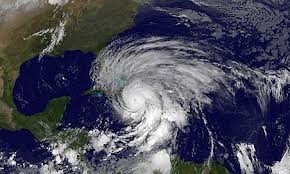
 Early Monday morning, Hurricane Sandy was lurking offshore like a heavyweight boxer winding up a wallop of a punch.
Delmarva — which gets its name from the three states that occupy parts of it: Delaware, Maryland and Virginia — was just one of many population centers along the East Coast where residents were bracing for or backing away and heading inland from anticipated walls of wind and water.
What to expect:
Strong winds
Hurricane-force winds will pummel the coasts of Delaware, New Jersey and New York state, with tropical-storm-force winds stretching from North Carolina all the way to Maine. Likely immediate impact: downed power lines and extensive power outages.
Storm surge
The highest storm surge will occur along the coasts of New Jersey, New York and Connecticut, especially where water funnels into New York Harbor and Long Island Sound. Immediate impact: coastal flooding and beach erosion.
Flood-triggering rainfall
Heaviest rainfall of up to 8-12 inches will be likely on the Delmarva Peninsula and in New Jersey. Immediate impact: Cities such as Dover, Delaware; Baltimore, Washington and Philadelphia could see significant flash flooding.
Snow
Extreme snowfalls totaling several feet will be likely in the Appalachian Mountains of West Virginia and to a lesser extent into portions of Pennsylvania and Virginia as well.
Flight delays
With major airlines canceling many flights even ahead of the storm, air travel will be extremely difficult for all of the major Northeastern cities from Washington through Boston both Monday and Tuesday. Impact: The ripple effect on air travel will be felt worldwide as flights arriving and departing will be canceled or severely delayed.
Timing
Conditions will be deteriorating along the Mid-Atlantic into the Northeast through the day Monday. Landfall will occur Monday evening into overnight, and storm surge likely will peak around the evening high tide. (Remember Monday’s tides are already the largest of the month due to the full moon.) On Tuesday, rain and snow will continue for much of the area and surf will remain very rough as the center of the system slowly drifts northward into Pennsylvania and New York.
Delayed impact
Because of the size of this system, many impacts will be felt far from the center. For example, large waves and surge will be felt in eastern Canada and along the shores of the eastern Great Lakes. Also, when Sandy transitions from hurricane or tropical storm to “post-tropical storm,” it does not mean that the storm has weakened or that the threat is any less.
CNN
For live updates on Sandy click on Google crisis map

Leave a Reply
You must be logged in to post a comment.