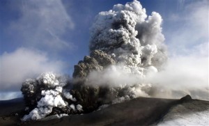
 When ash spews from an Icelandic volcano, 10 British scientists using laser sensors, satellite pictures and a specially equipped jet must tell the world where it’s going.
The grit can block flight paths and shut airports, so the fate of millions of travelers, and billions in revenue, rides on the projections of the Volcanic Ash Advisory Center in Exeter, about 200 miles (320 kilometers) southwest of London.
Their British base — one of nine global volcanic ash advisory centers — has been on high alert since Iceland’s Eyjafjallajokul (pronounced ay-yah-FYAH-lah-yer-kuhl) volcano erupted in April, shutting down global travel for five days. It has caused sporadic disruptions since then, closing London’s Heathrow and Amsterdam’s Schiphol Airport — two of Europe’s busiest hubs — over the weekend.
One rattled airline executive — Ryanair’s Michael O’Leary — has already attacked the “imaginary black plumes” predicted by the team’s computing models, which he blames for prompting excessive caution and wrongly curtailing air traffic.
“When you get a big volcanic event it gets very, very busy and very, very stressful,” said Tony Hall, director of the National Oceanic and Atmospheric Administration’s Alaska Volcanic Ash Advisory Center in Anchorage.
“These things can go on for weeks, or months — it can be a very stressful time,” said Hall, who has had contact with his colleagues in London since Eyjafjallajokul’s eruption.
Sarah Jackson, the British center’s atmospheric dispersion group manager, said the scientific model used to predict the spread of ash — and other dangerous particles — was developed to track contamination from the 1986 Chernobyl nuclear reactor disaster.
In a video produced by the office to explain its work, she said the modeling uses latest available data and then takes into account wind patterns and the effects of turbulence, ash settling on the ground, and washout caused by rain or snow.
But, the scientists themselves acknowledge their predictions can be sketchy, and warn that long-term forecasts are rarely correct. They caution that all estimates of ash movement can quickly become outdated as wind patterns change.
Keith Groves, executive director of Britain’s Met Office — the country’s national weather forecasting service, and a commercial arm of the defense ministry — said the scientists use sophisticated equipment and have a strong record in their assessments.
“We’re quite confident that we’re producing accurate and useful predictions,” Groves said, in a video produced by his office.
The British staff tracked emissions from the 1991 Kuwaiti oil fires in the first Gulf War and a major 2005 fire at an oil depot north of London, the biggest blaze in Europe since World War II.
To predict the path of the ash, they scrutinize reports from Iceland, sift through reports from airline pilots flying over Europe — known as pireps — and consult satellite and polar orbiter imagery of the ash cloud. Data is also collected from laser sensors, called lidar — or light detection and ranging, based around Britain and used commonly in atmospheric research and to monitor cloud particles.
More data comes from research flights, including a jet owned by Britain’s Natural Environment Research Council — used almost daily through April to test the composition of the ash clouds, check the size of the ash particles and monitor levels of sulfur dioxide.
Those flights have sometimes been perilous — on May 4, a journey from southern England to Scotland was aborted after sensors detected a rising levels of ash particles. Ash can clog jet engines.
Hall said staff at the volcanic ash centers input data into computers running weather and ash dispersion modeling software. Resulting maps showing where ash clouds are likely to travel are then either hand drawn, or printed.
Scientists keep in regular contact with their overseas counterparts by e-mail and phone, updating each other about their latest predictions.
Through April, British forecasters prepared 18-hour projections of the movement of ash across Europe, as regulators carefully monitored the safety of the continent’s airspace. Beginning last week the ash experts have also published five-day forecasts, on the orders of Britain’s new government.
Met Office spokesman John Hammond stressed the new five-day charts are only an indication of the likely volcanic activity, and said that long term predictions of wind patterns are notoriously unreliable.
Some tour operators and airlines say they’re skeptical that the scientists can make any accurate long term predictions.
Frances Tuke, a spokeswoman for ABTA, the Association of British Travel Agents, said the new charts can only go so far to eliminate travelers’ uncertainty.
“It is helpful, but we do have to give it a degree of caution. Our experience has shown so far that this is quite a dynamic situation that can change rapidly,” she said.
But Ryanair’s O’Leary said the new charts should be scrapped, and the entire process of predicting the ash cloud’s movement overhauled.
“It is frankly ridiculous that the flight plans of millions of air passengers across Europe are being disrupted on a daily basis by an outdated, inappropriate and imaginary computer-generated model and it is time that these charts were done away with,” he said. AP

Leave a Reply
You must be logged in to post a comment.