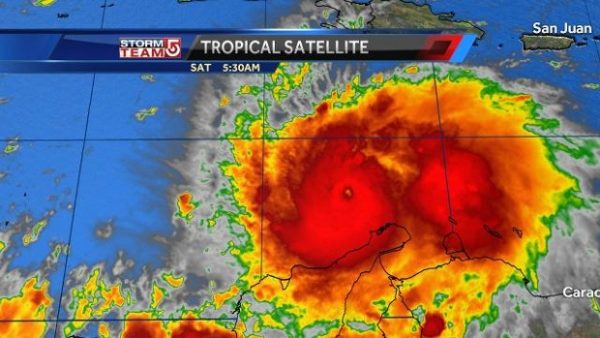
Matthew, weakened only slightly to a Category 4 hurricane, barreled through the Caribbean Saturday toward Jamaica and was expected to turn toward the north-northwest by day’s end to set a course possibly impacting the U.S. East Coast next week.
En route, it also threatens Haiti, Cuba and the Bahamas into Monday.
As of 2 p.m. ET, Matthew had maximum sustained winds of 140 mph (225 km/h) — 17 mph ( 27km) shy of the Category 5 status it reached Friday. The hurricane was moving erratically, the National Hurricane Center, with the center drifting southward at 7 mph (11km /h) for a few hours and was located about 400 miles ( 640 km) southeast of Kingston, Jamaica. It was forecast to regain its northward trek late Saturday, eventually turning north-northwest.
“Some fluctuations in intensity are possible during the next couple of days, but Matthew is expected to remain a powerful hurricane through Monday,” the NHC says.
Friday night, when Matthew roared to Category 5 status, it became the strongest Atlantic Ocean Basin hurricane since Felix in 2007, NBC reported.
The National Hurricane Center said Matthew was expected to turn toward the west-northwest later Saturday followed by a turn toward the north-northwest on Sunday.
A hurricane watch has been posted for Jamaica and portions of Haiti. The NHC said a hurricane watch could also be needed for portions of eastern Cuba by Saturday night.
AccuWeather senior meteorologist Bernie Rayno said if Matthew moves swiftly as it heads north, it has a greater chance of causing significant impact from rain, wind and flooding along much of the Atlantic coast.
“On the other hand, if Matthew’s forward speed slows, it could still have significant impact on the Atlantic coast, but in a much smaller area, when compared to a fast-moving hurricane,” he said.
The hurricane center’s five-day forecast cone — which marks the range of the storm’s possible path — includes a portion of southeastern Florida early Wednesday.
In Jamaica, Prime Minister Andrew Holness said government services have been placed on high alert, according to the Jamaica Observer newspaper. Thursday, fishermen on Jamaica’s cays and banks were advised to evacuate immediately and return to the mainland.
Other small-craft operators in the island’s coastal waters were told to return to port, while those in port were advised not to venture out, the newspaper reported.
The hurricane center also warns of likely life-threatening surf and rip-current conditions over a wide area from Puerto Rico to Venezuela.
In Jamaica, Prime Minister Andrew Holness said government services have been placed on high alert, according to the Jamaica Observer newspaper. Thursday, fishermen on Jamaica’s cays and banks were advised to evacuate immediately and return to the mainland.
Other small-craft operators in the island’s coastal waters were told to return to port, while those in port were advised not to venture out, the newspaper reported.
Florida Gov. Rick Scott said the state emergency operations centers were active Friday. He said state officials would continue to monitor Matthew’s path and urged residents and tourists to monitor the storm and have their emergency plan in place.
“While the National Hurricane Center’s current forecast predicts Matthew traveling east of Florida, we all know that the track of these storms can quickly change,” Scott said.
A hurricane is classified as “major” when its sustained winds reach 111 mph. A major hurricane is a Category 3, 4 or 5 on the Saffir-Simpson Hurricane Wind Scale. It’s the first major hurricane in September in the Caribbean since Felix in 2007.
Hurricane Matthew is the fifth hurricane and second major hurricane of the 2016 Atlantic hurricane season. It’s now the only hurricane or typhoon on the planet.
USA TODAY

Leave a Reply
You must be logged in to post a comment.