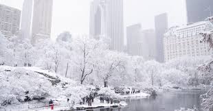
A major snowstorm is enveloping the Tri-State, with the brunt pummeling parts of the area Friday night, and continuing into early Saturday. Some areas will be on track to receive around a foot of snow if the heaviest bands deliver on their potential.
The storm is poised to become the most significant snowstorm to hit New York City in almost four years.
The snow, which has been heavy at times, greatly reduced visibility Friday night, making travel treacherous across the entire region, which is covered in a Winter Storm Warning from the National Weather Service.
The storm is powerful but fast-moving and front-loaded, and could deliver 1 to as much as 2 to even 2 1/2 inches an hour of snow at its peak intensity. This kind of intensity — an inch or more an hour — will challenge snow plows working to clear roads.
The worst began around 7 p.m. Friday and will continue until about 1 a.m., but moderate snow will still fall into the morning hours on Saturday.
Parts of the Hudson Valley, Connecticut and Long Island quickly wracked up snow totals, piling on 4-7 inches in some parts by 9 p.m. Friday. Totals were coming in much lighter in New Jersey in New York City.
The final totals will be a widespread 4 to 8 inches in New York City, but could wind up on the lower end. However, 8 to 12 inches of snow is still possible in the heaviest bands, largely north and east of New York City.
Those heavy bands will encroach the Hudson Valley, extreme northern New Jersey and even parts of Long Island.
The key question will ultimately be where those heavy bands set up, so there could be big differentials in accumulations within small geographic expanses.
Temperatures will remains cold, ensuring the precipitation stays as snow for much of the region, but sleet is expected to mix in to our south, keeping amounts in the 2-to-4-inch range in central and southern New Jersey, where warmer air aloft will keep totals down.
The storm is an Alberta Clipper which has been infused with energy from the Pacific storms delivering an atmospheric river of rain to the West Coast. As this system crashes into the cold air in our area, it will squeeze out a lot of snow in a hurry. Meteorologist Jeff Smith describes the system as an “Alberta Clipper on steroids.”
ABC