 AS THE Trump administration presses Arab countries to sign off on President Donald Trump’s Israeli-Palestinian “deal of the century” amid growing Arab polarization and vocal pessimism, little attention has been given to another sensitive regional matter that the administration has been aptly and quietly tackling. This matter revolves around the demarcation of the Lebanon-Israel maritime and land borders, which have been the focal point of skirmishes, a devastating war in 2006, and rising regional tension involving Iran and Israel.
Since last year, the Trump administration has been pursuing quiet shuttle diplomacy between Beirut and Jerusalem to demarcate their borders, while at the same time pursuing a policy of “maximum pressure” on Iran and Hezbollah. The accomplishments achieved thus far because of the administration’s efforts, led by acting Assistant Secretary of State David Satterfield, have been quite impressive. Even if their success is incomplete, these efforts could help the economies of both Lebanon and Israel. More importantly, it could decrease the risk of a devastating war with regional repercussions.
Satterfield has extracted some essential concessions from both sides. The negotiations over Israel-Lebanon’s borders are highly sensitive because they involve the exploration of energy in disputed maritime Mediterranean waters and a dispute over land borders, the latter of which has been the focus of armed conflicts and a focal point of national and regional conflicts.
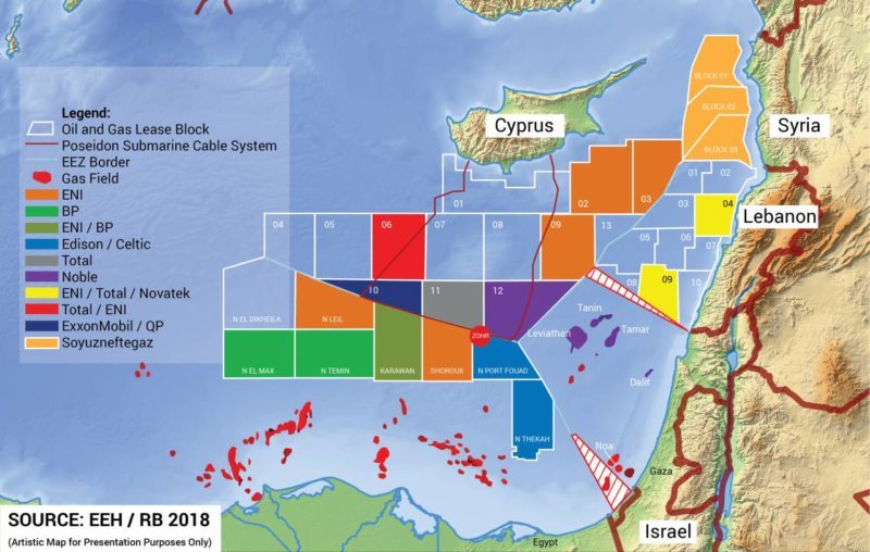
 THE DISCOVERY of enormous oil and gas reserves in the Mediterranean has been auspicious for the economies of both Israel and Lebanon. The former is already producing gas from several gas fields, including Tamar and Dalit, and is preparing to produce gas from the Leviathan gas field, operated by the energy giant Noble Energy. Additionally, Israel is expanding its offshore exploration efforts via a second bid round, hoping to attract investment via exploration licenses in the country’s waters in the Mediterranean. Moreover, Israel and Cyprus have signed agreements delineating their maritime borders and are embracing further economic cooperation with assistance from Noble Energy.
The eagerness with which Israel would like to produce gas from these fields, especially Leviathan, and press ahead with its economic cooperation with Cyprus (with Greece to follow), is hedged by concerns about possible armed conflicts with Lebanon’s Hezbollah, due to disputes over the boundaries of these two countries’ exclusive economic zones. Lebanon and Israel both claim an area that is approximately 860 square kilometers in size. In fact, in 2011, the Obama administration’s special Middle East envoy, Frederic Hof, proposed what came to be known as the “Hof Line,” whereby Lebanon would have 550 square kilometers of the disputed area and Israel would take the rest. Lebanon rejected the proposal. In fact, last year Lebanon notably signed off on contracts with giants Total, Eni and Novatek to explore energy in its exclusive economic zone—including in a block disputed by Israel. Total expressed its awareness of the dispute and stated it will drill away from the disputed area, which consists of less than 8 percent of the block under its contract.

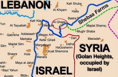
While the maritime border dispute may sound convoluted, it pales before the dispute over land borders. At the heart of this land border dispute are three areas: Shebaa Farms, Kfar Shouba Hills and Ghajar. The situation is complex and multi-faceted: there are disputes over the Lebanon-Israel border, the Israel-Syria border and Lebanon-Syria border. Additionally, there are inconsistencies in the Lebanon-Israel-Syria tri-border, which can be traced to the old British and French mandates over Lebanon, Syria and Palestine. Finally, the gradual evolution of the Arab-Israeli conflict, and the changes in de facto territorial ownership as a result of the conflict, adds an additional dimension of complexity to the situation.
Following twenty-two years of occupying a swath of southern Lebanon, Israel decided in 2000 to withdraw from Lebanon in accordance with un Security Council Resolutions 425 and 426. Yet the withdrawal created a problem over the exact location of the border, since Israel withdrew from contiguous Lebanese-Syrian and Israeli-Lebanese territories.
The Lebanon-Syria border was mapped by the French in 1920, but the exact boundary has not been delineated by Lebanon or Syria since their independence. The mapping of the Israel-Lebanon border followed the 1949 armistice agreement that corresponded with the British mandatory border. As for the border between Lebanon and Syria, there was no international boundary agreement between the two of them. As such, the un mapped the border relying on the separation lines of its troops in the Golan Heights and Southern Lebanon. In his report to the un Security Council, Secretary-General Kofi Annan, recognizing the lack of an international boundary agreement, recommended “to proceed on the basis of the line separating the areas of operation of unifil and undof [the un Forces in South Lebanon and the Golan Heights, respectively] along the relevant portions of the Lebanese-Syrian boundary…”
In short, following its own surveys of the region’s borders, the un simply drew the border demarcation, known as the Blue Line, and subsequently recognized the complete withdrawal of Israel from Lebanon as corresponding to the Blue Line. The Lebanese government and Hezbollah, with Syria’s consent, challenged the un position and declared that Israel’s withdrawal remains incomplete, since it still occupies the Lebanese Shebaa Farms. The un, adopting Israel’s position, emphasized that Shebaa Farms—located south of the Lebanese village of Shebaa, and comprising an area of 14 km in length and 2 km in width—are part of the Syrian Golan Heights.
Conversely, Lebanese authorities asserted sovereignty over the Farms by producing land deeds, official documents that place the Farms within Lebanon and pre-1967 tax receipts related to the Farms. These receipts indicated that taxes were paid by residents of Shebaa village (and adjacent town Nukheila) to the Lebanese government. Meanwhile, in response to Lebanon’s claim that Israel’s withdrawal is incomplete, Hezbollah asserted its right to continue its muqawama (resistance) against Israel.
THE DISPUTE over the village of Ghajar, meanwhile, is the product of both the Arab-Israeli conflict and a vagueness as to where the exact border between Lebanon and Syria lies. Essentially, there are no definite maps placing the village either in Lebanon or Syria. However, most of the Ghajar’s residents are Alawis and have been in close contact with their coreligionists in the Golan Heights, though many of them acquired Lebanese citizenship. When Israel occupied the Golan Heights in 1967, Ghajar residents found themselves in a political no man’s land. They petitioned Israel to recognize them as residents of the Golan. Israel subsequently offered them citizenship when it formally annexed the Golan Heights in 1981. Interestingly, Ghajar residents, unlike many residents of the Golan Heights, accepted Israel’s offer. During Israel’s occupation of southern Lebanon, Ghajar’s residents were able to travel unimpeded between Lebanon and Israel due to their dual citizenships.
When Israel withdrew from Southern Lebanon in 2000, Ghajar was split between Lebanon and Israel in accordance with the Blue Line, which cut across the village. As a result, the village was divided, with a majority of it formally located in Lebanon to the north, while the southern portion remained in Israel. Besides its militarily strategic position along the Israel-Lebanon-Syria tri-border, Ghajar’s boundaries scrape the Wazzani River, which is the main spring of the Hasbani River. This has led to tumultuous instances of water politics: Lebanese authorities have consistently accused Israel of trying to steal the water of the Hasbani, while Israeli authorities have been constantly worried about Lebanon diverting the waters of the Hasbani River.
During the 2006 conflict between Israel and Hezbollah, Israel took control of the whole village. unsc Resolution 1701, which ended the war, called on Israel to withdraw from the northern section of Ghajar. Israel, however, has not obliged, citing security considerations: in 2005, Hezbollah tried to kidnap Israeli soldiers stationed in the southern section of the village, and in the 2006 war, Ghajar was a fiercely contested area. The occupation of the northern section of Ghajar by Israel has thus reinforced both Lebanon’s claim that Israel’s withdrawal is not complete and Hezbollah’s right of muqawamah.
LAST BUT not least, the village of Kfar Shouba and its hills are another point of contention between Israel and Lebanon. Located in Lebanon, next to the Shebaa Farms and the Golan Heights, the village commands a military strategic position due to its location overlooking northern Israel and the Bekaa Valley. In the late 1960s and 1970s, the Palestinian Liberation Organization used the village as a steppingstone to conduct sabotage activities in Israel. In response, Israel heavily shelled the village and its hills and carried out punitive military missions there. In 1972, Israel occupied the village for a short period of time. Then, during Israel’s occupation of southern Lebanon (1978–2000), the Israel Defense Forces and their proxy militia, the South Lebanon Army, used the village as an important observation post. Subsequently, Israel withdrew from the village but kept occupying the hills and the lands of Kfar Shouba in proximity to Israel’s border for security reasons. In the 2006 war, most of the village’s homes were either destroyed or damaged. As was the case with Shebaa and Ghajar, Lebanon and Hezbollah have insisted on their right to resist Israel’s occupation until the hills of Kfar Shouba are retrieved.
NATIONAL INTEREST

Leave a Reply
You must be logged in to post a comment.